
What lies beneath
Frank Callery writes on the origins of the site of NCBI’s head office on Whitworth Road, Drumcondra, Dublin, and its developments in the late 18th and early 19th centuries.
The site of NCBI’s head office at Whitworth Road has a colourful past and Whitworth Road was not always Whitworth Road, it was first called Belvedere Street and came about in this manner.
With the increase in population and the growth of north Dublin city, it was necessary make new parishes for the Established Church. Under an act of Parliament passed in 1698, the old parish of St. Michan’s was divided into three separate parishes: St. Michan’s, St. Mary, and St. Paul; each independent of the other, and to have parochial rights as separate parishes — as from the 20th November, 1697.
St. Mary’s was again divided into the new parish of St. Thomas, and, in 1762, a newer parish of St. George’s was formed. In 1793 an Act of Parliament was passed to take in lands in the north east district adjoining the City of Dublin which had been extra-parochial. By this act, a piece of ground was laid out on the east bank of the Royal Canal, a short distance north of Binns’ Bridge and it was vested in trustees, for the purpose of erecting a new church and making a cemetery for the new parish.
The trustees erected a temporary chapel on portion of this new site, and in the old Dublin Directories, from 1794 till 1809, this temporary chapel is described as the “Church of St. George, “Belvidere” Street. In 1802 The trustees abandoned this site in favour of the newer Hardwick Street site and plans were prepared by Francis Johnston for the beautiful St. George’s, as we know it today — The one made famous in Jame’s Joyce’s Ulysses, in the Molly Bloom’s Soliloquy section. Francis Johnston died on the 14th March, 1829, and was buried in St. George’s Burial-ground, east side, (Behind NCBI) where a sarcophagus monument was erected over his grave. Francis Johnston had a peel of bells in his Campanile in the ground of his house at 64 Eccles Street Dublin. He gave these to St. George’s — the first time on which then rang was for his funeral. This peel of bells (in Bb, are now in the Church of Ireland, Taney, Co. Dublin)
St. George’s burial Ground, Belvidare Street
The plot of ground originally selected by the trustees for a cemetery, was situated on the north side of the Royal Canal, It was a narrow strip containing only three roods and four perches and it ran parallel to the Canal bank, from about a perch above the boundary, northward, of the present NCBI building, to the third lock above Binns’ Bridge. It had formerly been laid out as a nursery garden by the Huguenot community of Dublin.
In the beginning of Queen Anne’s reign, the Huguenots encouraged floriculture; and in George I’s reign, they, together with other French citizens formed a club, called the “Florists’ Club,” for the purpose of furthering the cultivation of flowers in Ireland. They held their meetings for many years at the Rose Tavern in Drumcondra Lane (now Dorset Street), where they adjudged premiums to the members who produced the most beautiful flowers.
“Whitworth Road”, as we know it, was not then formed. Luke Gardiner (afterwards Viscount Mountjoy, created 1st Nov., 1795), whose lands adjoined those of the Dean and Chapter of Christ Church — had plans to open such a thoroughfare. With the Rebellion of 1798, this fell through. Viscount Mountjoy was killed at the Battle of New Ross, on the 5th June, 1798, and was succeeded by his eldest son, Charles John, 2nd Viscount Mountjoy (born 19th July, 1782), who was advanced to the dignity of Earl of Blesington, County Wicklow, on 22nd January, 1816.
The piece of ground at the northeast corner of the new burial-ground, given for the site of the new church, was, in 1816, given by the Rt. Hon. John Ormsby Vandeleur for the purpose of erecting a fever hospital, which was opened on the 1st May, 1818, as The Whitworth Fever Hospital. The proprietors found that there was no convenient approach to it, either from Drumcondra or Glasnevin, except by a narrow lane leading as far as the hospital only, which, in former times, had been the only approach to the old nursery garden. To give a better entrance, the trustees gave their proposed new burial-ground (‘A’ on the attached Tercliart or map) in exchange for the present one, and a new road was made, named “Bishop’s Road,” (after The Bishop of Kildare, Charles Dalrymple Lindsay, D.D. (1760-1846) last Titular Bishop of Kildare, prior to the amalgamation of the Diocese of Kildare and Dublin in 1804 whose lands adjoined these) which was later changed to “Whitworth Road” — after Charles Earl Whitworth, Lord Lieutenant of Ireland, 1813-1817.
The Earl of Blesington availed himself of the opportunity for carrying out the improvements which his father had planned and gave, in exchange, the piece of ground on his own estate to the trustees of the parish, in lieu of that which they purchased under the Act of 1793. This was conveyed by an Indenture of Agreement duly executed on May 14th 1818. It mentioned “All that parcel of ground within the said intended parish thereinafter described, that is to say, that piece of ground at the north corner of a new intended street to be called Belvedere Street.
“That piece or parcel of ground situate on the north of the new road leading from Glasnevin-road to Drumcondra-road and containing by survey three roods and four perches of land, in the possession of Mr. James Sullivan or his undertenants, on the west to ground belonging to the Dean of Christ Church, and on the south by another part [now the Whitworth Hospital] demised to the Right Hon. John Ormsby Vandeleur and Thomas Burton Vandeleur, Esqs., together also with the use of the lane or passage, of twenty feet wide, leading from the said new road to the hereby granted and re-leased premises, situate lying and being in the parish of Saint George, Barony of Coolock, and County of Dublin, and are more particularly laid down and described in the map or tercliart delineated on these presents, and marked ‘B’ on the said map”. The new cemetery was opened for interments in 1817, but apparently not consecrated until the 20th of May, 1824.
The adjoining property (at North) was then known as “The Bishop’s Fields,” after the Right Rev. Charles Lindsay, to whom a lease of the lands was made on the most favourable terms. That part of the “Bishop’s Fields,” the northern boundary of the old Cemetery of St George’s, was later let during the small-pox epidemic to the Guardians of the north Dublin Union, for erecting hospital sheds. This Bishop, Charles Lindsey the last Protestant Bishop of Kildare, had given his beautiful house at Glasnevin to the Dublin Harp Society, (where the blind harper Patrick Quin was to be instructor). This harp school, which like that at Belfast (conducted by the blind harper Arthur O’Neill) was one of the early schools for blind people in Ireland.
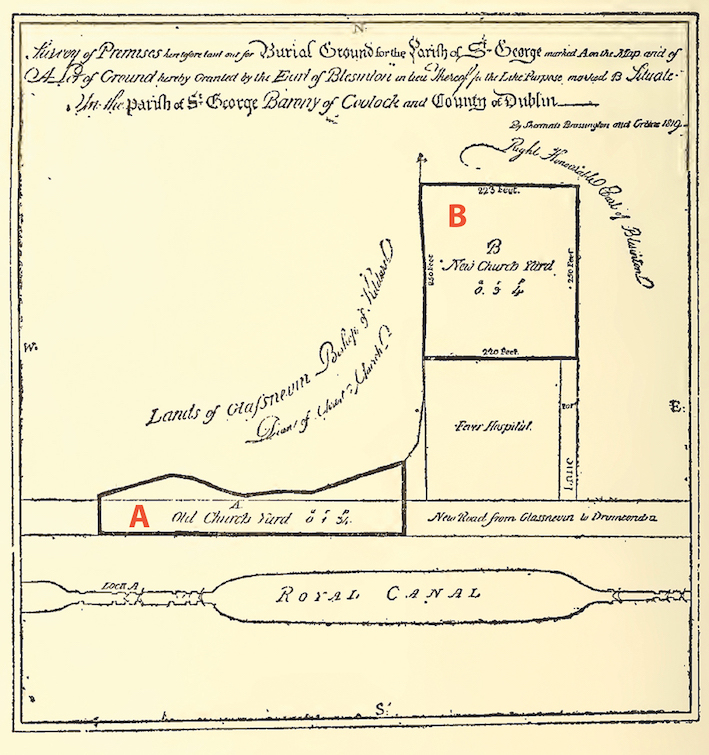
Tercliart or map of the two burial grounds and the hospital site.
Whitworth Fever hospital
The Hospital (erected on the proposed site of St. George’s Church and on which had been erected the temporary church) was opened on the 18th of March, 1818, for the reception of persons labouring under infectious fever, and residing in the north side of the city. It was built, and was entirely supported, by voluntary subscriptions. It was capable of supporting fifty patents. Mr. Thomas Burton Vandeleur of Gloucester Street, mentioned above, was on the management committee. The Vandeleurs were lawyers who had property dealings with Luke Gardiner. They were members of a prominent landowning family of Dutch origin who settled at Kilrush, Co. Clare, in the 1680s.

An early photograph of Drumcondra Hospital.
